The Gus Luck Track
Eastern Goldfields, WA
There is not an “official” Gus Luck Track currently (in 2009) recognised by Western Australia’s Geographic Names Committee, the body that administers the naming of the State’s geographical features including roads. This does not mean that there was not a Gus Luck Track in the past or that a track should not be called that today.
Gus Luck
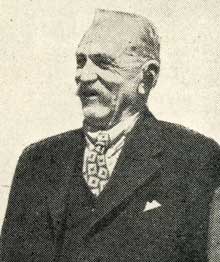
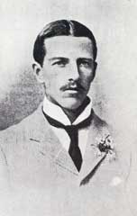
Gus Luck (August Jules Luck, 1867-1958) was a WA goldfields character. It is said that the explorer David Carnegie learnt his bushcraft skills from him; and on the 27 April 1894, Carnegie named Mt Luck after him.
A Gus Luck family tree
On a map prepared by Carnegie to accompany the report on his famous 1896 - 1897 expedition from Coolgardie to Halls Creek and return (this map shows the route to Halls Creek) he marked the track of the 1894 excursion with words “Carnegie and Luck 1894”. On this trip Gus Luck carved “A.J. Luck” in a rock at Mt Shenton.
The 1894 excursion started on March 24 from Kurnalpi, travelled eastward to Queen Victoria Spring, then north to Mt Venn and Mt Shenton, and then meandered south westerly to end at the Mt Margaret mining centre.
Some believe the route for that excursion is known as the “Gus Luck Track”.
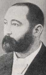
David Carnegie
H H Wilson in her book Westward Gold notes:
Gus Luck seems to have to been an outstanding character in his own right. A native of Alsace, he spent some years in the Foreign Legion before coming to Australia. He surveyed roughly the track between Southern Cross and Menzies, a distance of 150 miles, having to cut scrub part of the way to allow his camels to get through. Later he sent the map to the Water Supply Department for monetary reward. Not only was it refused, but the map was never returned. However, much later the new road followed the map.
This provides an alternative route for a "Gus Luck Track". There is more detail on Luck seeking recompense for the track in the book The Outback Trail:
Warden Finnerty
... I thought that I would go and see Warden Finnerty about recompense for opening the track from the 90 Mile to Southern Cross. When I got there Finnerty was lying down on a bunk in his tent. I asked him politely if he could spare me a few minutes. This he granted. I told him I had given the plans and directions to the Water Supply officers. I had hardly got the words out of my mouth when he jumped up and said “Go, I will have nothing to do with it. Why didn’t you come to me? I am the man you should have come to. I have nothing to do with it.”
“But” I said – I had known Finnerty before – “I ask you as man to man, what I am to do about it?”
He lay back on his bunk and said “Excuse me. I have had a bad morning and have a headache. If you make out the plan and directions again and send them to me I will see what I can for you.”
I expressed my sorrow to have disturbed him and hoped he would soon be alright. [p61].
In the early 1900s there are a few references to the “90-mile Road” in newspapers and in at least one government file. One recent Department of Environment and Conservation document indicates that the Gus Luck Track begins at Yellowdine (east of Southern Cross) and ends at Goongarrie. An early document refers to a Southern Cross Wangine Road.
Gold was discovered at Goongarrie by May 1893 by Billy Frost and Jack Bennett. This was before gold was discovered at Kalgoorlie so it is hardly surprising that a track from Southern Cross to Goongarrie came into being. Originally the township that sprung up was called the 'Roaring Gimlet', and then the '90 Mile' (the distance from Coolgardie) before officialdom settled on 'Goongarrie'. In October 1893 gold was discovered at Siberia by Frost and Bonner which lead to a disastrous rush in which many lives were lost. An 1895 Coolgardie District Map shows that many tracks existed through the eastern goldfields. Several maps have been examined in the WA State Records Office but thus far none have been found that clearly sets out this track.
The definitive route cut by Gus Luck could possibly be found in the Salvation Army’s The War Cry as Gus Luck recorded that he was approached by a Salvation Army Officer for a donation as an issue contained a picture of him with camels and facts about the track. It appears likely that he is referring to the article written by Ellen Arnold that appeared in the 16th December 1893 edition.
Any road from Southern Cross to Goongarrie or Menzies would have fallen into disuse when the Kalgoorlie Menzies railway was completed in 1898. When it was decided to clean out the wells, soaks and rockholes on the “old goldfields road” from Southern Cross to Menzies the following were maintained:
Duladgin Soak No 1. Gus Luck refers to Dulatgin in his writings but not in reference to the track.
Duladgin Soak No 2
Weeowanie Rock Hole
Darrine Soak No 1
Darrine Soak No 2
Willumbay Soak
Willumbay Rockhole
Walangie Soak
Deep Well (71 Mile Well)
Deadman Soak
Udaruing Soak
Nearnging Soak No 1
Nearnging Soak No 2
Coomine Soak No 1
Coomine No 2 Soak
Most of these sites can be plotted on present day maps. Doing that does not provide a definitive track. It is unclear what route the road followed from Southern Cross to Duladgin and it is unclear whether the road ended at Goongarrie or Menzies. It could have followed the old Goldfields Stock Route as far as Duladgin. This Stock Route which ran from Southern Cross to Coolgardie was closed in the early 1900s on the instigation of Walter Edward Luyer.
Gus Luck mentions that J J K Cohn built a hotel on the track 30 miles from Southern Cross. Isodere James Knight Cohn died in Perth on the 4th July 1922 aged 86.
One source suggests that the Gus Luck track was a Cobb & Co route. The dates need further investigation to substantiate this claim.
It is is likely that parts of the original road are still used as roads and are in reasonable condition. Other parts may have degenerated into rough tracks suitable only for four-wheel drive vehicles. Other parts will have disappeared for ever. One magazine article claims a track, known as the Gus Luck track, was constructed in 1901 with the route described as being from Yellowdine to the goldfields at Siberia. Siberia is about 30 kilometres south west of Goongarrie and about 60 kilometres south of Menzies. The track described in the magazine can be followed by four wheel drivers today but the trip needs careful planning.
References:
Anon (Department of Environment & Conservation) (2008) Management Plan for Northern Yilgarn (Mt Manning Range, Mt Elvire and Jaurdi) Conservation Reserves - Issues Paper accessed March 2009 at www.dec.wa.gov.au/component/option,com_docman/gid,2226/task,doc_download/
Carnegie, David W (1897) Map Shewing routes of the Exploring & Prospecting Expedition between Coolgardie & Kimberley Western Australia Equipped and Led by the Hon David W. Carnegie. Hesperian Press Carlisle WA republication.
Department of Mines (1894) Plan shewing country north of Coolgardie
Feeken E H J, Feeken G E E, & Spate O H K (1970)The Discovery and Exploration of Australia Thomas Nelson
Luck, Gus (1988) The Outback Trail Hesperian Press, Carlisle WA.
Underwood, N (2008) “North-East to Siberia” in the Western 4WDriver Issue 67 (Winter 2008 ed)
Wilson H H (1973) Westward Gold! Rigby.
Acknowledgments:
Peter Bridge of Hesperian Press
Kevin Chatfield (descendant of Gus Luck)
George Herring (descendant of Gus Luck)
Jenny Kolen of The West Australian
Nick Underwood of the Western 4WDriver