King Rockhole
Rippon Hills Road, East Pilbara, Western Australia
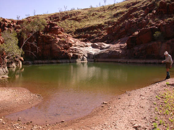
J Gilbert Marsh (22 November 1925 - 22 June 2017), former CALM volunteer and Mains Road Department engineer examines the rockhole (August 2004).
The first record of King Rockhole occurs in D.I. Glendinning's 1957 field notebook. In 1957, Doug Glendinning undertook a two-month trip in the east Pilbara. The aim of the trip was to verify the ten map sheets that been produced using aerial photographs (600 per map sheet). He was accompanied on the trip by a surveyor, Kevin Pownall and his driver. He was told this was to "stop him from getting lost". In 2004, Doug does not recall King Rockhole in particular, but says most of the place names came from station owners. He says some explorers named features of the landscape after barmaids!
Doug Glendinning worked for the Land and Surveys Department for forty-five years and has been retired for some time. Initially he was a cartographer. In 1988/89 he was sent overseas (to Holland) to learn photogrammetry. After returning to Perth, Doug reorganised the cartography section of the Lands and Surveys Department. The Mains Roads Department provided the funding for most of the new equipment. Their engineers needed accurate maps and realised the potential of the new methods that Doug wanted to introduce. At the time of his retirement, Doug Glendinning was the Superintendent of the Mapping Section of the Lands and Surveys Department.
The Lands and Surveys Department is now known as the Department of Land Information.
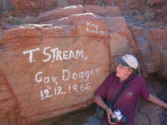
Emma Williams of Biddulph Moor (UK) contemplates the words painted on a rock by former government dogger Tom Stream.
Painted on a rock are the words "King Rock Hole", "T Stream" and "Gov [Government] Dogger 12.12.1966". Tom Stream was born on Corunna Downs Station which is south of Marble Bar. He died in Port Hedland in 2007.
References:
Department of Land Information (DLI) Geographic Names Database, Perth WA.
Glendinning, DI (2004) Personal communication